Horses in Paris

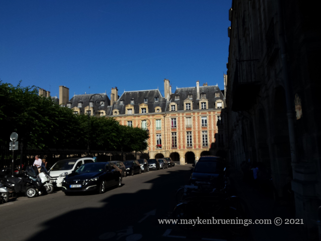
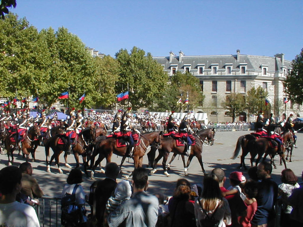
Have you been in the area between the Place de la Bastille and the Seine and happened to cross riders on horseback?

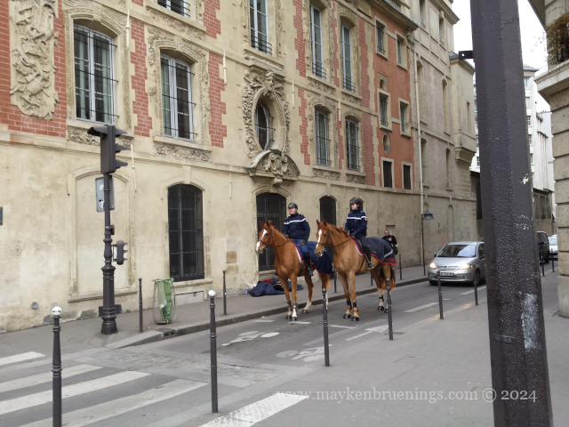
Chances are you met members of the Garde Républicaine, the Republican Guard, on patrol. Yes, those same ones you see parade on July 14 on the Champs Élysées.

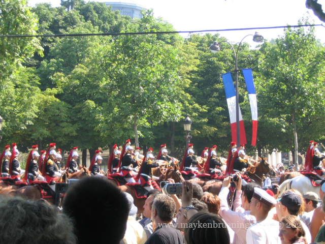
Note the traditional helmets which date back to 1876, inherited from the dragoons and cuirassiers of the First Empire.

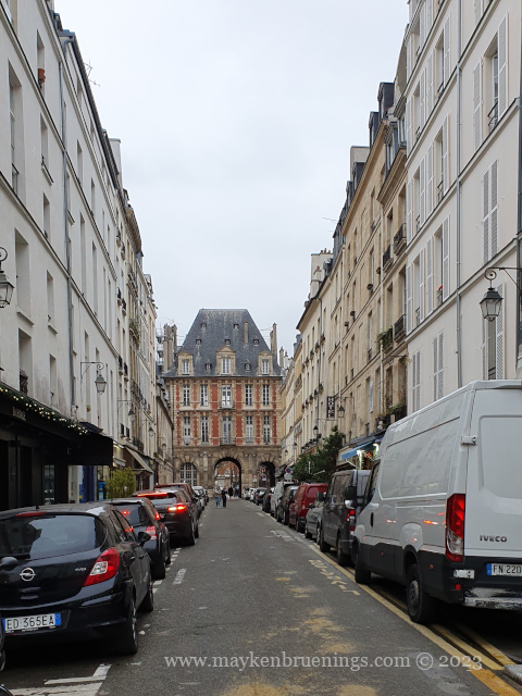
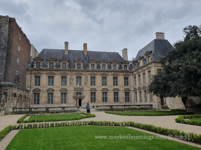
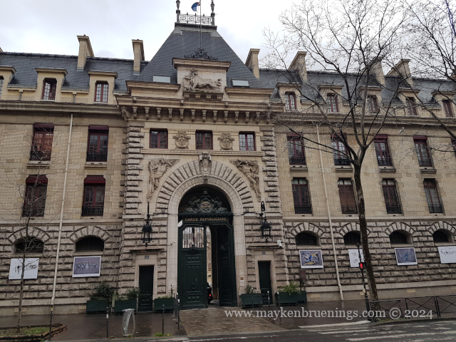
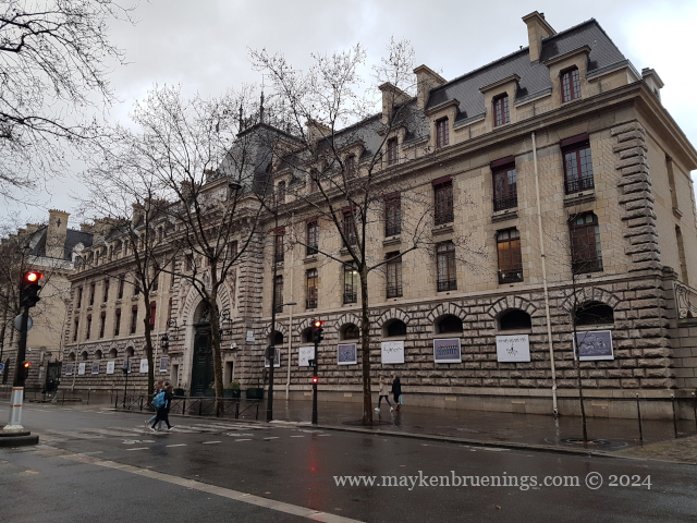
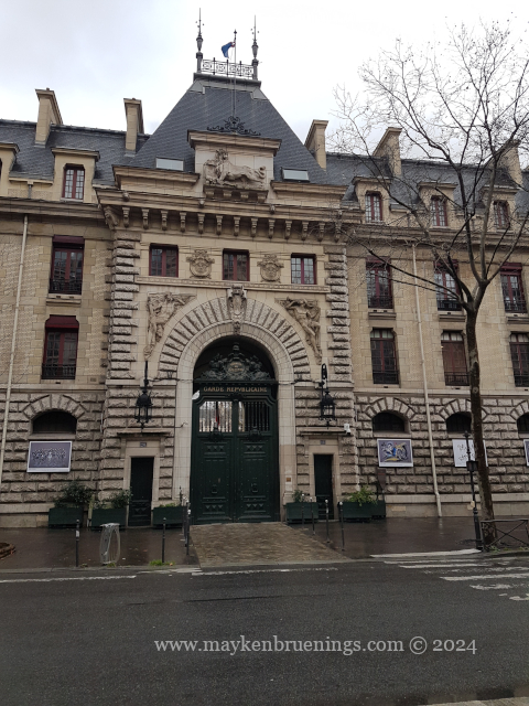
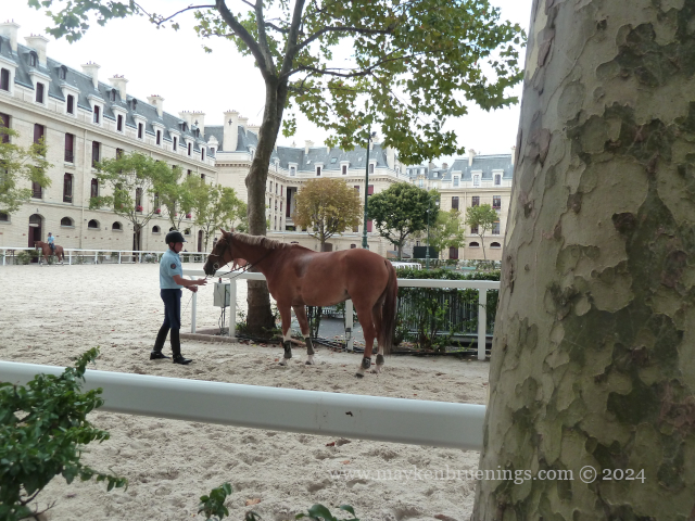
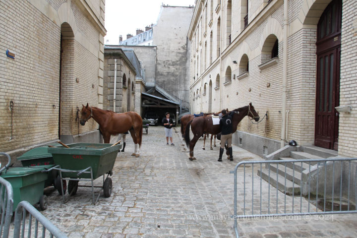
The cavalry of the Republican Guard is housed in the Célestins Quarter with its main entrance on boulevard Henri IV.

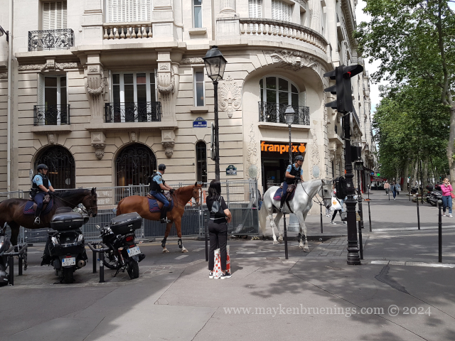
Its most visible role is in the honor missions (escorts, also carried out by the motorcycle squadron) although those represent only about 20% of the total. The majority consists of security missions such as patrols in Paris, the Bois de Boulogne and the Bois de Vincennes, but also in the forest of Chambord royal palace and other royal forests.

Chambord Palace

They also carry out surveillance of the sites at summit meetings for certain sports events and in areas with difficult access, for example a missing person search in the woods, and also surveillance of tourist areas.

Napoléon Ier

The origins of the Republican Guard go back to Napoléon Ier, who created the Municipal Guard of Paris in 1802. After many back and forth over the turbulent period of the early 19th century, it was integrated into the Gendarmerie in 1849 by Napoléon III.

Contrary to other cavalry units, the Republican Guard did not participate in WWI as its mission was to maintain order in Paris and oversee the city’s defense. That is how it survived as the last mounted regiment.
During WWII, the Republican Guard was demobilized and attached to the Police Prefecture under the name of Paris Guard. Part of the troops secretly joined Charles de Gaulle, and the Guard participated with the French Forces of the Interior in the combats for the liberation of Paris.
The Guard also participated in the Indochina War from 1947 to 1954, and in 1978 it changed its name back to Republican Guard.

President Emmanuel Macron initiated a “horse diplomacy” by giving a Republican Guard horse to the Chinese president in 2018. He gifted another Republican Guard horse to Queen Elizabeth II for her Platinum Jubilee in 2022.

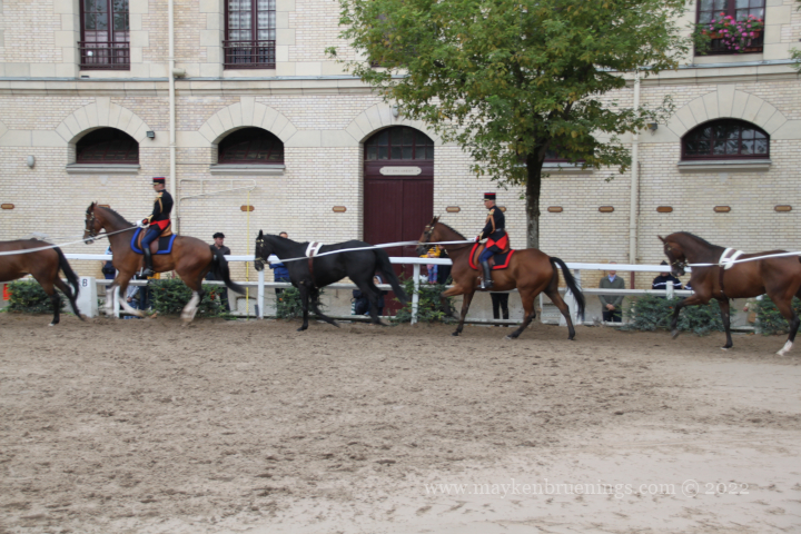
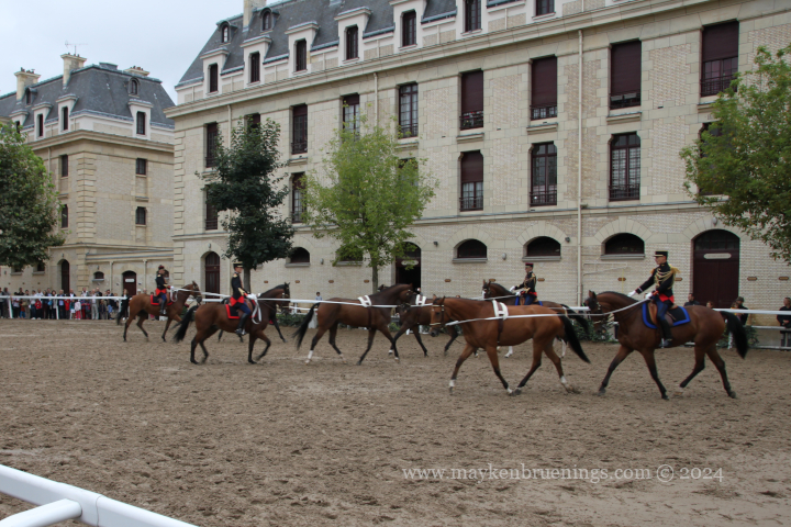
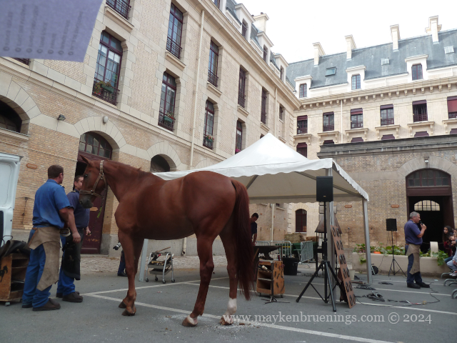
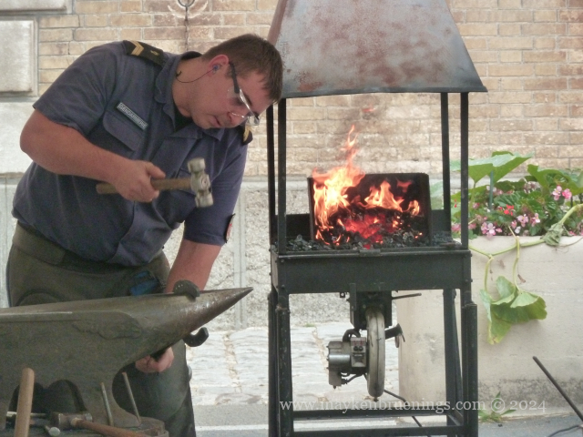
On Heritage Days in September, the Republican Guard will open the doors of the Célestins Quarter where you can see riding demonstrations, visit the horses in their stables and see the blacksmith at work.

Did you know the horseshoe sizes range from 28 to 50, with the smallest fitting inside the largest?

Republican Guard at Célestins Quarter

At the Paris International Agricultural Fair 2024, the Republican Guard, including their fanfare or orchestra, put on an impressive show. A few highlights below.

Share this:

Meridians and Paris Time

Did you know that for a while, official Paris time was 9 minutes and 21 seconds ahead of Greenwich Mean Time (GMT)? Let me tell you how that happened.

First of all, I assume you know a meridian is a line that runs from the North Pole to the South Pole. It is used to indicate the longitude of a location.

The Royal Observatory, Greenwich

The Royal Observatory, Greenwich (a town just outside London), is the reference point for both the Prime Meridian, putting Greenwich at 0° longitude, and Greenwich Mean Time. Both these references were progressively adopted around the world over the second half of the 19th century, some international conferences helping the process along.

The Prime Meridian at the Royal Observatory, Greenwich

Paris is in the GMT+1 time zone and at a longitude of ~2°20’E. New York is in the GMT-5 time zone and at ~74’W.

Back in the 17th century, Sun King Louis XIV authorized the building of the royal observatory of Paris (today the Paris Observatory). On Midsummer’s Day 1667, scientists traced the outline of the building in such a way that the Paris Meridian bisected the site from north to south. Meridians were really important in that time as scientists attempted to determine the size and the figure of the earth.

The Paris Observatory

So we now have the Paris Meridian. What about Paris time?

Once upon a time and ironically long before the Sun King came along, people told time by the sun. Later, church bells calling to prayer marked time during the day. Each village, each town lived by the time of their local clocks.

It was only with the arrival of the train that France started to feel the need to unify time across its territory. In order to assure a regular train service, the train companies used Paris time. Progressively, over the second half of the 19th century, French towns adopted double display, local time and Paris time, and in 1891, Paris time was enforced by law across the country.

However, in the meantime, the Greenwich Meridian and GMT had been widely adopted around the world, first by navies, then by train companies and then (nearly) everyone else.

Finally, with the law of March 9, 1911, France adopted the time of the Greenwich Meridian and the division of the day into 24 hours instead of two times 12 hours. However, the text of the law never mentioned Greenwich. Indeed, the reference time remained “Paris time” which is 9 minutes and 21 seconds ahead of GMT. This corresponds to the distance between the Paris Meridian and the Greenwich Meridian.

La Mire du Sud – a sight that originally stood on the Paris Meridian in the gardens of the Paris Observatory, allowing to focus on the Meridian (today it can be found in the public Parc Montsouris)
Paris Observatory and Paris Meridian

In Paris, the Meridian is materialized both inside and outside the Observatory, as well as across town by the Arago medallions, named for Astronomer François Arago (1786-1853) whose statue near the observatory was destroyed by the Vichy Regime in 1942.

Many of the Arago medallions have gone missing since their installation in 1994, not least due to the Da Vinci Code, which has their location all wrong, so don’t go looking for one at the Louvre Pyramid! (Please don’t take any of the remaining medallions. Eiffel Tower key chains only cost 0.50€.)

And if you go to Villers-sur-Mer  in Normandy, you will find a marker materializing the Greenwich Meridian on the beach wall. That’s how much 2°20’ are in distance!

Location of the Paris Observatory on a map of Paris
Share this:

On the Road with Smart Bison

The French love going on holidays in their own country. Annual leave stands at five weeks and school holidays in the summer at two months, so there’s plenty of time to choose from and many lovely places to go to. Mer ou montagne? (Sea or mountains?) you will hear, or Mer ou campagne? (Sea or countryside?) In the end, lots and lots of French holiday-makers will head for the Mediterranean or the Atlantic coast in July or August. As holiday rentals start and end on Saturdays in high season, I’ll let you guess on which day traffic volume is highest.

Queuing for cheap gas at the start of summer holidays

Back when autoroutes were built and expanded and more and more people got cars, a traffic information system slowly developed. It got a big boost after tragedy struck during an August Saturday in 1975 when a combination of heat wave and traffic accidents killed almost 150 people.

Authorities realized they needed to work on three main points:

  • Spreading the traffic over a larger time period
  • Reinforcing alternative itineraries
  • Communicating with the travelers
The Saint Arnoult toll station, with 39 toll gates one of the biggest in Europe, a dreaded congestion point on holiday weekends

It was in this context that Bison Futé (Smart Bison) was created, a character who’d tell people the smart time to travel to avoid traffic congestion, and the alternative routes to take.
You’ll have guessed given the time (1970s) and the name, what this character was. Fortunately, French authorities have gone with the times, and the present logo of Smart Bison is the outline of a bison head made to look like an itinerary. The Smart Bison has become an icon that couldn’t simply be removed.

The Smart Bison website is run by the Transport Ministry, and both website and the Smart Bison Twitter feed will also warn of adverse weather conditions, like heavy thunderstorms.
But its main focus is traffic. Smart Bison will tell you if it’s a green, orange, red, or black day for departures and for returns.

  • Green means normal traffic (including rush hour traffic in urban areas)
  • Orange means heavy traffic with difficult driving conditions locally or generally
  • Red means very heavy traffic with very difficult driving conditions locally or generally
  • Black means traffic is extremely heavy and driving conditions are extremely difficult on the entire road network

For example, on July 12, 2023,  a Wednesday preceding the weekend with the national holiday July 14 falling on the Friday, and school holidays having started the previous weekend, Smart Bison predicted the following traffic conditions for the weekend:

Thursday
Departures
Orange everywhere but red in the greater Paris area
Returns
Green everywhere

Friday (national holiday)
Departures
Orange in the north and northwest, including the greater Paris area
Green for the rest of the country
Returns
Green everywhere

Saturday
Departures
Red for the entire country
Returns
Green for the entire country

Sunday
Departures
Orange for the entire country
Returns
Orange for the entire country
Red for the greater Paris area

The pattern here is easy to spot:
It clearly was a weekend of departures, not returns, with a peak on Saturday (remember those holiday rentals?). The Red for the greater Paris area and Thursday for departures and Sunday for returns indicates many Parisians going away for the long weekend.

Not all that hard to read, is it? So next time you plan to drive in France, consult Smart Bison!

Share this:

Places des Vosges

The Place des Vosges is one of the five Royal Squares in Paris. Inaugurated in 1612, it was initially named Place Royale after kings Henri IV and Louis XIII. Its name was changed to Place des Vosges in 1792 for the département Vosges in eastern France which was the first to pay its taxes under the French Revolution.

This royal square for once is a square, 140m to each side, with identical façades all along, two stories high, built of red bricks with strips of stone quoins. On the ground level, vaulted arcades allow pedestrians to go around the entire square shielded from the elements.

Only at the center of the north and south sides, the pavilions of the Queen and the King rise above the regular roofline. Despite all those names, the only royal who ever lived on the Place des Vosges was Anne of Austria, and even her residence in the Pavillon de la Reine was short-lived.


At the center of the square stands the equestrian statue of Louis XIII. The original statue, built in 1639 was destroyed during the revolution.
Up until the revolution, the square served as a meeting place for the nobility. Today, when the weather is fine, it becomes a meeting place for families, friends, students, and kids’ birthday parties.

Over time, the square has seen many famous residents come and go. The most well-known is probably Victor Hugo who lived at number 6, house which is now the Victor Hugo museum. Other writers who lived on the square include Colette, Alphonse Daudet and Georges Simenon. It was also home to contemporary French politicians like Jack Lang and Dominique Strauss-Kahn. It is said that even Cardinal Richelieu lived at number 21 for a while.

The numbering begins at the rue de Birague at the south side of the square with the Pavillon du Roi being number 1. From there, it’s rising even numbers to the right-hand side and rising uneven numbers to the left-hand side, making the Place des Vosges an exception to the systematic street numbering in Paris.

rue de Birague and the Pavillon du Roi

The square can be accessed via the rue de Birague on the south side, which connects the Place des Vosges to the rue Saint Antoine, the rue des Francs Bourgeois from the Marais on the northwest corner, the rue du Pas de la Mule at the northeast corner from the boulevard Beaumarchais, and through a door in the southwest corner leading into the gardens of the Hôtel de Sully.

exit from the Place des Vosges in the southwest corner

If you leave the Place des Vosges this way, you can cross the courtyard of the Hôtel de Sully and emerge onto the busy rue Saint Antoine which a little further becomes the rue de Rivoli, a main east-west axis of the city.

Hôtel de Sully on the rue Saint Antoine
The location of the Place des Vosges on a map of Paris
Share this:

A rail belt around Paris

In the mid-19th century, a train track was built circling Paris like a belt just inside the boulevard des Maréchaux (see The Adolphe Thiers Wall). Called La Petite Ceinture, or Little Belt, it had junctions with all major train lines, so there was no need to go to the terminus stations. Initially meant for freight traffic, it started opining to passenger trains in 1862, giving workers relatively moderately priced train service through the suburbs of the capital to which Baron Haussmann’s works had relegated them.

Ouest Ceinture station near Porte de Vanves

At the end of the 19th century, another belt-like railway line was built, 15km outside the Boulevard Périphérique (which roughly corresponds to the official city limits). This was called La Grande Ceinture and meant to connect the radial train lines linking Paris to the rest of the country and relieving the Petite Ceinture.

Nevertheless, peak traffic of 39 million passengers was reached on the Petite Ceinture during the 1900 World Fair. However, afterwards Parisians gradually abandoned the line in favor of the newly created métropolitain and omnibuses, which provided alternative offers better adapted to urban needs.

The Montrouge station on Avenue du Général Leclerc in the 14th has become a restaurant, behind it (to the left), there’s a staircase giving access to the Petite Ceinture.

The train line closed down definitely in 1934. It was immediately replaced by a bus line taking its name, shortened to “PC”. Only a few night trains still ran for a while, freight trains kept running until the 1990s.

A passenger train on the Petite Ceinture for a special occasion in 1992

The PC bus line has since been partially replaced by the T3A and T3B trams, but the last section between T3A terminus Pont du Garigliano and T3B terminus Porte d’Asnières is still served by the PC bus.

The Petite Ceinture infrastructure was largely abandoned and is today invaded by vegetation, which has given the line a special atmosphere and allowed for the development of a unique biodiversity in Paris.

Since 2007, the national French railway company SNCF, has authorized the temporary creation of greenways on certain sections. By preserving the platform, the SNCF keeps the option of one day reopening the line to passenger traffic.

There is one exception though: On the stretch between Avenue Henri Martin and Porte de Clichy stations, the RER C trains still run on the Petite Ceinture platform.

the Petite Ceinture near Vaugirard

There used to be an entrance to the Paris Catacombs in the Montsouris tunnel, and even today adventurers out for the (completely illegal) exploration of the catacombs can be spotted in certain spots of the train track in the 14th arrondissement.

At Poterne des Peupliers in the 13th arrondissement, the train tracks were used for test runs of the new fully automatic metro line 14 before it was put into service in 1998.

The Petite Ceinture rail line (in purple)
Share this:

World Fairs in Paris

World Fairs, or universal exhibitions, exist since the industrial revolution in the 19th century. Since 1931, they are overseen and regulated by the International Bureau of Expositions.
The first World Fair was held in London in 1851. It is said to have been inspired by the French Exposition nationale des produits de l’industrie agricole and the Exposition des produits de l’industrie française, the latter having existed since 1798.

Prior to 1931, 20 World Fairs were held, five of those in Paris. As in other countries, these Expositions universelles, despite consisting mostly of temporary structures, have left a mark on the host city.

1855

The Palais de L’Industrie was built on the Champs Élysées. It was inaugurated by Napoléon III and was the emblem of the World Fair which had over five million visitors. Contrary to the Crystal Palace of the 1851 London World Fair, the Palais de l’Industrie was meant to become a permanent exhibition space.

1867

The second World Fair to be held in Paris took place on the Champ de Mars, as decided by emperor Napoléon III three years prior. The transformation of Paris by Baron Haussmann had just been completed. On the Champ de Mars, a military site, a giant oval building was constructed, the Palais Omnibus. A young entrepreneur specializing in metallic structures, was tasked with building the galérie des machines, where cranes, weaving looms, machine tools, power hammers, locomotives etc. would be displayed. His name was Gustave Eiffel.

1878

The third Paris World Fair was again held on the Champ de Mars. For the occasion, the Palais du Trocadéro was built on the opposite bank of the Seine, on the Chaillot hill (la colline de Chaillot).

No longer does the Palais du Trocadéro stand on the colline du Chaillot!

One of the main attractions of the exhibit was the head of the Statue of Liberty, and among the inventions presented was Alexander Graham Bell’s telephone.

1889

The tenth World Fair and fourth to be held in Paris, celebrated the centenary of the French Revolution. As a result, European monarchies refuse to attend. However, some of them were represented by private initiatives. The Fair was held mainly on the Champ de Mars but also on the Esplanade des Invalides.

Its main attraction, while controversial at the time and destined to be dismantled after the end of the fair, can still be visited there today.

1900

The fifth Paris World Fair was no longer restricted to the Champ de Mars. While previous World Fairs already includes the Jardins du Trocadéro on the south-eastern slope of the Colline de Chaillot and the Esplanade des Invalides, this fair also occupies the riverbanks on both sides of the Seine, from the new Pont Alexandre III to the Pont d’Iéna.

While the Pont d’Iéna links the Champ de Mars to the Trocadéro, the Pont Alexandre III links the Esplanade des Invalides on the left bank to the Champs Élysées on the right bank. Two palaces were built for this World Fair in the place of the Palais de l’Industrie, demolished in 1896: the Grand Palais and the Petit Palais.

Aerial view of the Grand and the Petit Palais
The Petit Palais

Of those five Expositions universelles held in Paris, it is the 1900 one that has left behind the most landmarks and structures still in existence. Not only the Pont Alexandre III built in a way to allow for a view from the Champs Élysées past the Grand and Petit Palais and across the river to the Esplanade des Invalides and the Invalides itself, but also the Gare d’Orsay (today Musée d’Orsay), the Statue of Liberty on the Pont de Grenelle, and, above all, the first sections of the Métropolitain, inaugurated on July 19, 1900.

The Musée d’Orsay still looks like the train station it once was.
The Statue of Liberty on the Pont de Grenelle
early métro trains looked like this

Take a ride on métro line 1, the first métro line which, at its inauguration in 1900, ran from Porte de Vincennes to Porte Maillot.

Share this:

Bones beneath the Stones

When you find yourself with an avalanche of human bones in your basement, you know it’s time for change.

Which is what the city of Paris did when exactly that happened to neighbors of the Cimetière des Innocents in 1774. Looking for a place to store the bones from the overflowing inner-city cemetery, they came up with the idea to put them in the decommissioned stone quarries underneath the city.

After arrangements had been made, bones from the various cemeteries of Paris, Les Innocents included, were carted to a chute in the avenue René Coty (near Place Denfert-Rochereau) to be stored underground. The name Catacombes was borrowed from Ancient Rome, even though there were no graves and funerary monuments. At first, the bones were stacked along the tunnels over hundreds of meters. It was only after the first VIP visits at the beginning of the 19th century that the bones were somewhat organized. More cemeteries had to be closed as the city grew, and their bones were added to the ones already in residence.

Signs were added to indicate the cemetery of origin, and the gravediggers arranged skulls and bones in patterns that can still be seen today.

In 1809, the Catacombes became a museum that today is part of the Musée Carnavalet and gives visitors access to a small fraction of the tunnel network of Paris’ ancient stone quarries.

In one of the first sections of the visit, sculptures made by a quarryman in the late 18th century can be seen. They represent sites from Port-Mahon on the Spanish island of Minorca where he was said to have been a POW.

There used to be a long line of visitors starting out from the old entrance and winding back around the square behind the eastern lodge of the barriére d’Enfer (entry point of the General Farmers’ Tax Wall), but recently, it was closed in favor of a new entrance, and the ticket sale has shifted online, so now visitors can book their spot in advance and don’t need to queue any longer.

signage in the métro station Denfert-Rocherreau
N° 2: Catacombes entrance, n° 5: Catacombes exit
Location of the Catacombes entrances on a map of Paris
Share this:

European Heritage Days – French edition

The European Heritage Days, based on an initiative of the then French Minister for Culture, Jack Lang, in 1984, now exist in 50 countries across Europe. In France, the Journées Européennes du Patrimoine, take place on the third weekend of September. This means sites that are usually closed to the public will be open, other sites will be free of charge, many will offer special activities and/or guided tours. Some will require reservations, but many will just let you drop in, from well-known institutions in big cities to ancient buildings in small villages. Often there will be activities for younger visitors.

At some point, when you got in line at 5am at the Elysée Palace, you might be lucky and shake hands with the president, or do the same with the prime minister after queuing at the Hôtel Matignon. I once stood in line at the Senate, the Palais du Luxembourg and indeed met the president of the Senate, the upper house of Parliament. He is the third person of the state in order of importance, after the president and the prime minister, and before the president of the national assembly.

Gérard Larcher, President of the French Senate

I am not sure though if you still queue for these institutions nowadays or sign up online, as I did to visit the National Assembly, the lower house of Parliament, more recently.

When you choose your visits, don’t overlook small events. You never know a hidden gem until you find it. For example, on year in the Latin Quarter, a college offered the visit of ongoing preventive archaeology digs – it turned out there were Gallo-Roman ruins on a site marked for construction, and archaeologists were trying to unearth and save as much as they could. This is something that will never be seen again!

Here are glimpses of some other interesting places I’ve visited during Heritage Days in and around Paris over the years:

King George VI’s bathtub at the French Foreign Ministry
Share this:

Bilingual Brittany

Before Brittany became part of France in the 16th century (see my post here), it was an independent duchy. The Breton language, a Celtic language related to Welsh, Cornish and Cumbric, was used there for many centuries, since before the year 1,000. It evolved from Old Breton over Middle Breton to today’s Modern Breton. The number of speakers fell dramatically in the mid-20th century due to the national policy of recognizing only French as official language in the 19th and 20th centuries.

Today, however, the Breton language is part of the regional Breton movement, and there are not only over 50 Breton-speaking schools (Diwan schools) but also numerous private Catholic and public schools with Breton classes.

The Diwan school association estimates the number of Breton speakers at 400,000. (Brittany has around 3,3 million inhabitants.) However, many Breton speakers are elderly people, and few actually use it in everyday life.

Five times so far, France has chosen to be represented at the Eurovision Song Contest with songs in regional languages, twice of those in Breton: in 1996 and in 2022. Numerous books and comics have been translated to Breton, local hero Asterix among them but also Belgian reporter Tintin, as well as the Peanuts.

When you visit Brittany, you won’t see it much until you are about halfway into the region. That is where the bilingual signposts will start, and where municipalities will put up signs with “Welcome” and “Goodbye” (Kenavo). However, the deeper you advance into Brittany, and especially in the département Finistère, you will see pretty much all signage in both languages, whether street names, the tourist office, the train station, or “other directions” (da lec’h all).

If you compare terms, you will be able to figure out some words. Ty, for example means house, and ker means town. So what might a ty ker be? A town hall, of course. My personal favorite is one I discovered this summer, a municipal library, or ty boukin.

The départements of Brittany (including historically Breton Loire-Atlantique)
Share this:

A Palace for Stock-Trading

Prior to the 19th century, stock trading took place in different spots of Paris. Napoleon Ier instigated the construction of a building to provide a stable location for stock trading activities.
Paris being Paris, the construction works running from 1808 to 1826 yielded not just any building but a palace – the Palais Brongniart.

The Bourse de Paris was integrated into Euronext in the year 2000, and today the Palais Brongniart has become a convention center, offering 4 000m² of exhibition surface and accommodating 200 000 visitors per year.

The Palais Brongniart on a map of Paris
Share this: